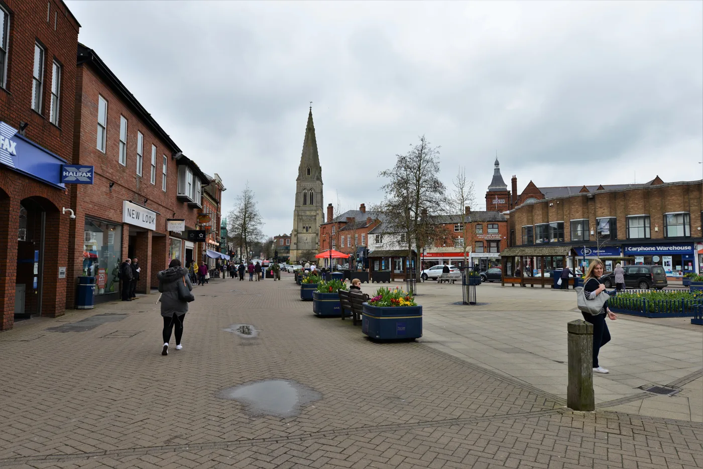

The county's report into the 21 September 2024 flash flood finds the risen Welland covered two drain outlets. 37 town centre businesses flooded inside.
Thirty-seven businesses in Market Harborough town centre were flooded inside on the evening of Saturday 21 September 2024. Leicestershire County Council’s formal investigation into why has now been published.
Its finding is that the River Welland did not burst its banks. Instead, the river rose high enough to cover the two pipes that drain the town centre into it. With those outlets under water, rain pouring down the High Street had nowhere to go.
The council, as lead local flood authority, has a legal duty under section 19 of the Flood and Water Management Act 2010 to investigate floods like this one. Its 45-page report is listed on the council’s formal flood investigations page.
What happened that evening
Businesses and the public reported the flooding between 5.40pm and 6pm. The report says the storm was “short and flashy”. Water ran down Burnmill Road and Bowden Lane, met at the bottom of Leicester Road, and poured into the town centre.
The streets where businesses were flooded inside were:
- High Street
- Church Square and Church Street
- The Square
- Adam and Eve Street
- St Mary’s Place
- Northampton Road
Water was reportedly up to 300mm deep, enough to top the kerbs. Businesses described it as anything from “damp carpet” to “ankle deep” and “reaching skirting boards”.
The roads stayed open, and cars kept driving through. The report says the bow waves they pushed out made the flooding worse inside shops with low doorsteps.
Two restaurants cancelled bookings at the peak of Saturday evening trade. Other businesses closed for all or part of the weekend to clean up. Losses included stock, flooring, plasterwork, alarms and IT equipment.
Why the drains could not cope
The town centre sits at the low point where three small valleys meet. It is almost entirely paved, and the clay ground underneath drains poorly, so rain runs straight off.
The main drain under the High Street is an old stream. The report traces it to an open channel that once ran the length of the High Street and across The Square into the Welland. It was later put in a culvert and now forms an 800mm brick sewer owned by Anglian Water.
That sewer empties into the Welland through two outlets on the river’s north bank:
- one directly south of the Memorial Gardens
- one on the downstream side of the Northampton Road bridge
Neither outlet has a flap. On the afternoon of the flood, rain across the wider Welland catchment pushed the river up by about 0.96 metres. It peaked at 6.15pm, around 15 minutes after the town centre flooded.
The report compares the river level with the depth of the pipes feeding those outlets. It concludes that both outlets were “fully submerged during the entire flood event”. The sewers backed up, and water surged out of gullies and manholes onto the roads.
Anglian Water surveyed the network afterwards and found no blockage in the main sewer. The report concludes its design capacity “was likely exceeded”. Anglian Water’s 2,000 cubic metre storage tank under The Commons car park worked as intended, pumping round the clock from 21 to 24 September, and did not add to the flooding.
The river itself came nowhere near the town’s flood wall. Its peak of 76.28 metres above sea level was about 1.5 metres below the top of the defence in The Commons car park.
How much rain fell
Market Harborough has no rain gauge of its own, so the report uses the six nearest Environment Agency gauges. They show how patchy the storm was. Kibworth, 4.7 miles away, caught 32.9mm in three and a half hours. Husbands Bosworth, 5.7 miles away, caught 4mm.
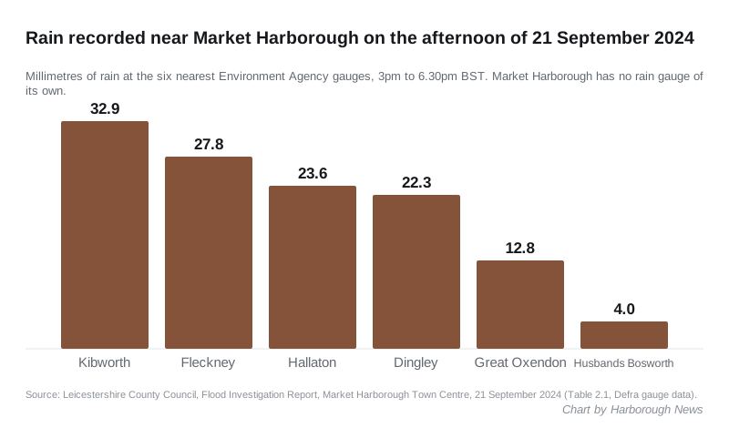
All six gauges recorded:
| Gauge | Distance from town centre | Rain, 3pm to 6.30pm |
|---|---|---|
| Kibworth | 4.7 miles | 32.9mm |
| Fleckney | 6.5 miles | 27.8mm |
| Hallaton | 6.6 miles | 23.6mm |
| Dingley | 2.5 miles | 22.3mm |
| Great Oxendon | 3.0 miles | 12.8mm |
| Husbands Bosworth | 5.7 miles | 4.0mm |
Was there any warning?
Only a little. The Met Office issued a yellow thunderstorm warning covering the town at 11.33am the day before. That morning’s Flood Forecasting Centre statement put the chance of surface water flooding at “low”.
The centre was trialling a rapid flood alert for emergency responders at the time. It issued one at 4.22pm, about 75 minutes before the water arrived. No Environment Agency flood alerts or warnings were issued, because the Welland never reached the trigger level.
A town that floods
The report gives the town’s long record. It quotes a 1959 council report: “Wherever one travels about the country and Harborough is mentioned the response seems to be, ‘Ah, yes. How are the floods?’”
River defences built in 1967 largely stopped the Welland itself flooding the centre. Surface water flooding from drains has carried on. The report lists town centre floods in 1975, 1999, 2000, 2001, 2002, 2006, 2008, 2012 and 2013. The July 2013 flood affected more than 50 properties and was also formally investigated. Its cause was the same: intense rain the drains could not take.
What has been done since
The report’s action list is short, and most of it is marked complete:
- Anglian Water surveyed the sewer from the Folly Pond on Leicester Road down to the river, updated its maps, and cleared some tree roots and silt. It found no blockage.
- County highways cleaned the town centre gullies straight after the flood. They were already on the top cleaning tier, every 10 months, and stay on it.
- The Canal and River Trust confirmed the canal has no link to the town centre drains.
- The Folly Pond has a flow control owned by Anglian Water. Whether it could hold back more water will be looked at as part of a longer-term review.
- A Market Harborough Flood Action Group was set up in 2025.
Two long-term actions are still open. The county council and Anglian Water are exploring whether more flood storage could be found in the town centre. The county council is also “exploring funding options” for flood protection for High Street businesses and at-risk homes.
None of the listed actions deals with the two submerged outlets directly. The report makes no commitment to new drainage works, and gives no date for either open action.
What it means for you
If you run a business or live in the town centre, the report’s message is that this will happen again in a heavy enough storm. It recommends:
- signing up for Environment Agency flood warnings; the town centre sits in the River Welland in Market Harborough warning area, code 055FWFUWEL01
- fitting property-level protection, such as flood doors or barriers, and keeping valuable stock off the floor
- reporting blocked gullies or drains to the county council
The report credits hard floors and quick clean-ups with letting many businesses reopen fast.
You can contact the county’s flood team at flooding@leics.gov.uk. Harborough District Council’s climate impact officer offers flood resilience advice at flooding@harborough.gov.uk.
If you drive through a flooded street, go slowly. The report is clear that bow waves from passing cars pushed water into shops that might otherwise have stayed dry.
Sources
- Flood Investigation Report: Market Harborough Town Centre, 21 September 2024, Leicestershire County Council, for every figure, quote and action in this article.
- Formal section 19 flood investigations, Leicestershire County Council, the index of published reports, including the July 2013 town centre report.
Have your say